The summer on the Pacific is determined by the Pacific High. To understand take a map - oops, a chart (which is a nautical "map") - and draw a line from Los Angeles to Hawaii. Now draw an equal sided triangle with this line as the bottom side, and the third corner of the triangle being north of it. This third corner is (very roughly) the expected position of the Pacific High. Finally draw a circle touching every corner of the triangle. Within this circle you will not find any other Highs or Lows or other disturbances. The wind along the race track is fully determined by the Pacific High and the costal influence of California, overlaid with some benign, global-scale weather effects. Any interested novice will be able to figure out how to sail. This scenario is forming stably every summer. At least this is what the textbooks say; now look at the real world.
On the right sidebar you'll now find a small picture of a weathermap. Click on it, and you will -always- get the most recent one, published by the NOAA. Find Hawaii at about 21N/157W, and LA at 34N/118W and figure out where the triangle would be. It is not hard to see that the current weather isn't near the textbook thing; in fact it is particularly ugly! Maybe some few NOAA guys can figure out where the wind blows, but I doubt any of the sailors in this race can. And if they could, what about the next 10 days?
Fortunately, computer technology has brought additional options. NOAA is doing a global scale weather model on the computer, updated every 6 hours. The results are publicly available; we need the wind section covering our race area. What we get (by email) is a computer file with numbers, only a computer can understand. The numbers provide wind speed and wind direction on e.g. a 1x1 degree grid, in time intervals of e.g. 24h for a total of e.g. 10 days. Admittedly, weather forecasts beyond 5 days may have a fairy tale nature, but this is all you have available. Find a program and print out 10 days of nice wind arrows on a chart. Then what? Think of stacking all 10 above each other, with 1 inch distance. Now you need to find the path from page to page to your destination. But this thread isn't a straight line. Not even in the space between two individual sheets, as the speed depends on the initial direction chosen, the location, the wind speed, wind direction, the time and the change of all of the above between sheets. So how can you figure out the best path? Easy answer, unless you're a braniac, you can't! Cirrugator comes to the rescue.
Cirrugator had accompanied Cirrus on the last three Pacific Cups in various forms. It is now a web application featuring also a router. A router solves the above problem, by "simply" calculating ALL possible routes - limited to a couple thousend - and then picking the best one(s). Of course it takes into account Cirrus' polars (which, in short, tell the program how fast Cirrus can go under which wind strength and wind angle). This takes a few seconds on today's medium-speed computers.
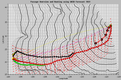
 This picture shows the router output valid for the start of the tp07 race last Monday. The black lines looking like wave fronts emanating from LA are "isochrones", lines Cirrus can reach in 1,2,3,... days. From that the seven best routes are picked, shown as diamonds; red is the best one. The tiny red arrows represent calculated, time and postion adjusted, wind strenght and direction. All routes are identical for the first week, only then, with diminishing forecast quality, do the routes diverge. Cirrus did not go as south as Cirrugator suggested, but given the conditions near LA this might have been easier said than done. Interestingly, though, Bill now says that he wants to again head deeper south.
To see the latest routing projections, click on the router map in the right sidebar. I am updating this regularly. If you want to play with the Cirrugator prgram itself, you can also do this. The link is above the routing picture. The program is running on my home computer, the one at which I am typing this now. It may feel a bit sluggish on occasion, since my upstream DSL speed will be the bottleneck. You will see everything what Bill sees on Cirrus, and you can do everything he can do, except modifying race data. When the captain says Bill is "punching numbers", this is what he is working with. Have fun.
Ulli


3 comments:
Wonderfully clear description, Ulli. Thank you!! Playing with the Cirrugator...who would have thought?!
You are most certainly a gen-you-wine genie-ous!
Very cool explanation. My only concern is about going south again. In the past these Southern Routes have been in search of wind but haven't always found the needed wind thus adding extra days on to the eventual ETA. I certainly hope this southern route works out. All I can say is Go go go Lindsey and Bill and crew!
And blow winds blow!
~kay~
Kay, I surely share your concern. If the forecast is right, then the decision is correct. But what if the forecast isn't? It has happened before (just read Bill's sigh on the recent delivery about differences in forecast vs. actual). And if you were deep south and all boats are passing north of you - man, you wouldn't want to go in the bar in the Honolulu marina without deepdark sunglasses, wig and fake moustache.
But take a look at todays routing results and the weathermaps (both in the sidebar), and tell on what grounds you would decide differently.
Ulli
Post a Comment